
No news yet, too early to pland anything or to know who might be attending.
The 'Cape Cod Circumnavigation Cruise' (a.k.a. CCCC, C(4), and Four Seas) will be a week long free flowing fun cruise around Cape Cod starting late July or early August of 2009.
In 2007 a full circumnavigation did not take place, but we did complete a modified circumnavigation and a great time was had by all.
The last cruise started at the site of the Black Dog Dash (a 23 mile not so serious race & fun event) in Vineyard Haven on Martha's Vineyard.
The route and stops for this year's cruise will be decided along the way by the participants based on the wind, waves, and weather, but possible stops include Nantucket, Chatham, Provincetown, Onset, Pocassett, Hadley Harbor, Edgartown, Waquoit, and a trip through the Cape Cod Canal.
Unknown at this point.
Some of us will be there from start to finish. Others may join in late or depart early. Each captain is free to make their own separate plans at any time.
| Ken Levitt & Judy Gould | Try Oomph | Corsair F-27 | Mattapoisett, MA |
| Jim Bourgoin | First Tri | Corsair F-27 | Wareham, MA |
| Chris Morris & Dale Lincoln | Silver Girl | Corsair F-27 | Fairhaven, MA |
| Bill Condon | Trinity | Corsair F-31 | Pocassett, MA |
We have started a group mailing list to help us organize the trip and for people who might be interested in joining us.
If you wish to subscribe to the CCCC mailing list, click to Contact List Manager and send us:
If your browser does not support scripts with email links, you will have to hand enter our email address into your email program. Due to the actions of spammers, we can not provide an easily readable email link, so you will have to type the address into your email program. To send us email, enter the user name of "Lst_Mgr42" then an at sign ("@"), and then "klevitt.us". We are sorry we have to obscure our address like this, but we would otherwise just get too much spam.
Members can add photos of themselves or their boat. After the cruise
we will publish trip photos & reports.
If you want to view the current photos, click on this picture of the boat.
Ramp Details: One lane, parking available, room to setup boat.
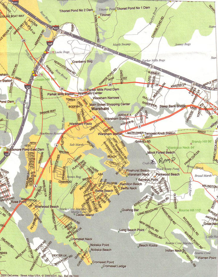
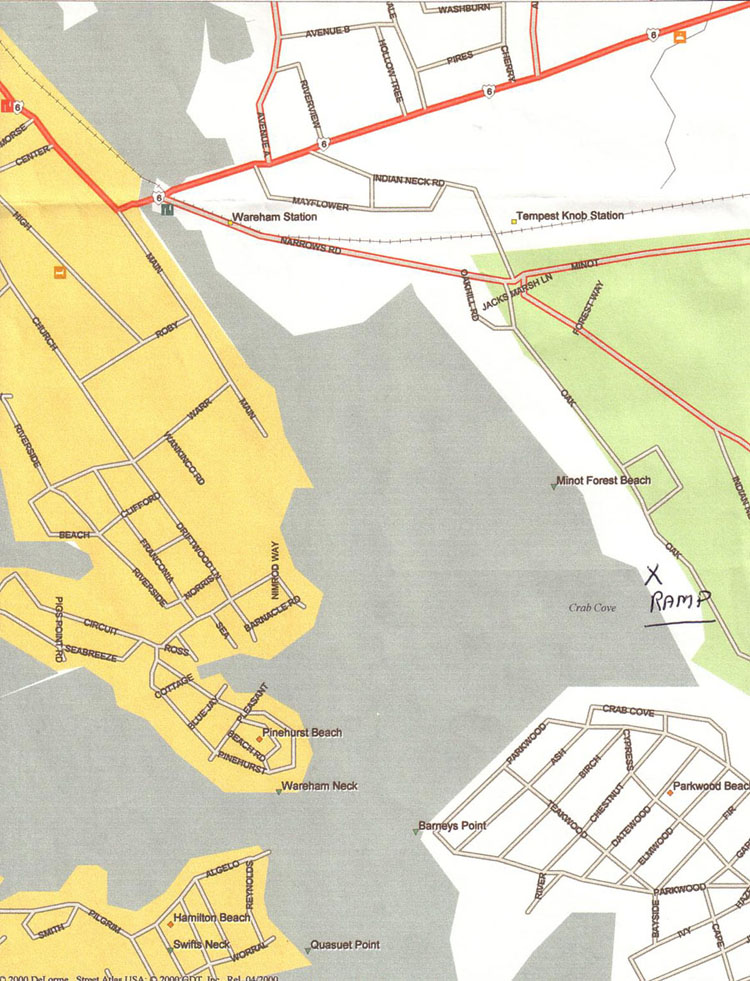
WAREHAM RIVER (Tempest Knob)
LOCATION: Oak St., Wareham, MA
Ramp Details: It is a very good double ramp with a large dock on the north (right) side. The ramp is well protected and there is a $5 fee per day (not per 24 hours) for using it or parking there and is payable at the ramp. (Must have exact change)
Room to setup boat. You may not find any parking spaces available on Saturday.
Stay on right side. Left side has trees that will snag a mast.
Road map showing the ramp - big picture: Map-1
Road map showing the ramp - detailed picture: Map-2
Chart of Wareham River: Chart
Driving Directions: From the North take I-495 South (towards Cape Cod).
Take the I-195 West exit to get to Route 28 (first exit on I-195 and
less than 1 mile from I-495). Once on Route 28 follow the signs to Main St.,
Wareham Center. Follow Main St. (Route 6) through town and at the traffic light
just over the Wareham River. Take a right on Narrow's Road.
Take your next right onto Oak Street and the ramp is a short distance on the right.
From the West use I-195 and take the Route 28 Exit (Just before the end of I-195). Then follow the above directions.
WARNING!!! If you are leaving from Wareham and headed through Woods Hole, you MUST pay attention to to the Woods Hold Tide Tables. You caould end up getting stuck in the middle (don't ask how I know this).
Units are knots. Flood Currents run West to East.
Tuesday ????-??-??
Sunrise: ?:?? AM EDT, Sunset: ?:?? PM EDT,
Moonset: ??:?? AM EDT, Moonrise: ?:?? PM EDT
  Max Flood:   ?:?? AM EDT   ?.?
Slack Water:   ?:?? AM EDT   ?.?
    Max Ebb:   ?:?? AM EDT  -?.?
Slack Water:  ??:?? AM EDT  -?.?
  Max Flood:   ?:?? PM EDT   ?.?
Slack Water:   ?:?? PM EDT   ?.?
    Max Ebb:   ?:?? PM EDT  -?.?
|
Friday 2009-??-??
  Max Flood:  ??:?? AM EDT   ?.?
Slack Water:   ?:?? AM EDT   ?.?
    Max Ebb:   ?:?? AM EDT  -?.?
Slack Water:   ?:?? AM EDT  -?.?
  Max Flood:   ?:?? PM EDT   ?.?
Slack Water:   ?:?? PM EDT   ?.?
    Max Ebb:   ?:?? PM EDT  -?.?
Slack Water:   ?:?? PM EDT  -?.?
|